 |
|||||||||||||||||||||||||||||||||
|
National Park and Surrounding Areas |
|||||||||||||||||||||||||||||||||
|
|
|||||||||||||||||||||||||||||||||
|
|
|||||||||||||||||||||||||||||||||
 |
|||||||||||||||||||||||||||||||||
|
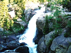
Waterfall elevation: 9,400 feet Trailhead elevation: 9,240 feet Net elevation gain: 160 feet Glacier Gorge Trailhead Rocky Mountain National Park |
|||||||||||||||||||||||||||||||||
|
Glacier Gorge parking lot, this popular trail leads to an overlook of Alberta Falls on Glacier Creek. |
|||||||||||||||||||||||||||||||||
 |
|||||||||||||||||||||||||||||||||
|
|
|||||||||||||||||||||||||||||||||
|
|
|||||||||||||||||||||||||||||||||
|
Glacier Basin and Bear Lake connector trail junctions (near the Glacier Gorge Trailhead) |
|||||||||||||||||||||||||||||||||
|
Bear Lake (0.5 miles one-way from trailhead) - via Bear Lake/Glacier Gorge connector trail Mills Lake (2.5 miles one-way from trailhead) - via Glacier Gorge Trail The Loch (2.7 miles one-way from trailhead) - via Glacier Gorge and Loch Vale Trails |
|||||||||||||||||||||||||||||||||
|
There are no designated campsites close to Alberta Falls |
|||||||||||||||||||||||||||||||||
|
|
|||||||||||||||||||||||||||||||||
|
Meadows Entrance Station on U.S. Highway 36, head west less than a quarter mile and turn south on Bear Lake Road (toward Moraine Park). Follow Bear Lake Road approximately 9 miles to the small parking area at Glacier Gorge. This lot often fills up early in the morning when Bear Lake Road is open to vehicle traffic. The trailhead begins across the road to the south. BEAR LAKE ROAD IS UNDER CONSTRUCTION AND VEHICLE RESTRICTIONS APPLY. Click here for more information. This is a short hike, and is only moderately steep (approximately 5 % grade). Alberta Falls is typically visited |
|||||||||||||||||||||||||||||||||
|
|
|||||||||||||||||||||||||||||||||
|
|
|||||||||||||||||||||||||||||||||
 |
|||||||||||||||||||||||||||||||||
|
|
|||||||||||||||||||||||||||||||||
 |
|||||||||||||||||||||||||||||||||
 |
 |
||||||||||||||||||||||||||||||||
|
|
|||||||||||||||||||||||||||||||||
|
|
|||||||||||||||||||||||||||||||||
|
|
|||||||||||||||||||||||||||||||||
|
Topographic map is property of and copyrighted by Maps a la carte, Inc., and is used on this site with permission. |
|||||||||||||||||||||||||||||||||