 |
||||||||||||||||||||||||||||||||||||||||||||||||
|
National Park and Surrounding Areas |
||||||||||||||||||||||||||||||||||||||||||||||||
|
|
||||||||||||||||||||||||||||||||||||||||||||||||
|
|
||||||||||||||||||||||||||||||||||||||||||||||||
 |
||||||||||||||||||||||||||||||||||||||||||||||||
|
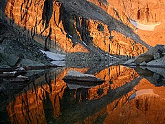
popular hike to one of the area's highest and most dramatic lakes. Nestled at the foot of Longs Peak's famous east face, Chasm Lake is a favorite destination for many hikers. The final 0.1 mile approach to the lake involves some basic route finding as the trail climbs a steep rocky area. |
||||||||||||||||||||||||||||||||||||||||||||||||
|
Lake elevation: 11,760 feet Trailhead elevation: 9,400 feet Net elevation gain: 2,360 feet Longs Peak Trailhead Rocky Mountain National Park |
||||||||||||||||||||||||||||||||||||||||||||||||
 |
||||||||||||||||||||||||||||||||||||||||||||||||
|
|
||||||||||||||||||||||||||||||||||||||||||||||||
|
|
||||||||||||||||||||||||||||||||||||||||||||||||
|
Junction of Chasm Lake and Longs Peak Trails (3.5 miles one-way from trailhead) |
||||||||||||||||||||||||||||||||||||||||||||||||
|
Mount Lady Washington (4.5 miles one-way from trailhead) - via Longs Peak Trail to an unmaintained route Mount Meeker (5.5 miles one-way from trailhead) - via Chasm Lake Trail to an unmaintained route Longs Peak (7.5 miles one-way from trailhead) - via Longs Peak Trail |
||||||||||||||||||||||||||||||||||||||||||||||||
|
Goblin's Forest (1.2 miles one-way from trailhead) - 6 individual sites Battle Mountain (2.8 miles one-way from trailhead) - 1 group site |
||||||||||||||||||||||||||||||||||||||||||||||||
|
|
||||||||||||||||||||||||||||||||||||||||||||||||
|
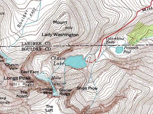
Meeker Park. Longs Peak Road provides access to the trailhead from Colorado Highway 7. Turn west on to Longs Peak Road from Highway 7 at a junction approximately 9 miles south of Estes Park, or 2 miles north of Meeker Park. Look for a left (south) turn to the trailhead parking area, about 1 mile from Highway 7, where Longs Peak Road continues straight (west) to the Longs Peak Campground. About 3.5 miles from the Longs Peak Trailhead, the Chasm Lake Trail splits from the Longs Peak Trail and heads south. This 0.7 mile trail to the lake heads downhill to a creek crossing just above Columbine Falls. Just beyond a Park Service patrol cabin, the trail disappears in the rock slabs, but routes to the lake are marked with cairns. Most of this trail is above timberline, so special attention must be given to weather conditions. Large snowfields near the lake may persist into summer months, and should be crossed with extra caution. |
||||||||||||||||||||||||||||||||||||||||||||||||
|
|
||||||||||||||||||||||||||||||||||||||||||||||||
|
|
||||||||||||||||||||||||||||||||||||||||||||||||
 |
 |
|||||||||||||||||||||||||||||||||||||||||||||||
|
|
|
|||||||||||||||||||||||||||||||||||||||||||||||
 |
 |
|||||||||||||||||||||||||||||||||||||||||||||||
|
|
|
|||||||||||||||||||||||||||||||||||||||||||||||
|
|
||||||||||||||||||||||||||||||||||||||||||||||||
|
|
||||||||||||||||||||||||||||||||||||||||||||||||
 |
||||||||||||||||||||||||||||||||||||||||||||||||
|
|
||||||||||||||||||||||||||||||||||||||||||||||||
 |
||||||||||||||||||||||||||||||||||||||||||||||||
 |
||||||||||||||||||||||||||||||||||||||||||||||||
 |
||||||||||||||||||||||||||||||||||||||||||||||||
|
|
||||||||||||||||||||||||||||||||||||||||||||||||
|
|
||||||||||||||||||||||||||||||||||||||||||||||||
|
|
||||||||||||||||||||||||||||||||||||||||||||||||
|
Topographic map is property of and copyrighted by Maps a la carte, Inc., and is used on this site with permission. |
||||||||||||||||||||||||||||||||||||||||||||||||