 |
|||||||||||||||||||||||||||||||||||||||||||||||
|
National Park and Surrounding Areas |
|||||||||||||||||||||||||||||||||||||||||||||||
|
|
|||||||||||||||||||||||||||||||||||||||||||||||
|
|
|||||||||||||||||||||||||||||||||||||||||||||||
 |
|||||||||||||||||||||||||||||||||||||||||||||||
|
Lake elevation: 10,582 feet Trailhead elevation: 8,470 feet Net elevation gain: 2,112 feet Finch Lake Trailhead Rocky Mountain National Park |
|||||||||||||||||||||||||||||||||||||||||||||||
|
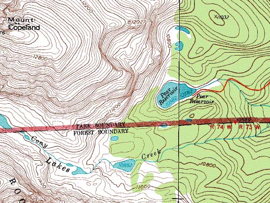
Lake Trail system leads through the south end of Wild Basin and Rocky Mountain National Park. Pear Lake was used as a reservoir at one time, but has been more recently restored to its natural water level. |
|||||||||||||||||||||||||||||||||||||||||||||||
 |
|||||||||||||||||||||||||||||||||||||||||||||||
|
|
|||||||||||||||||||||||||||||||||||||||||||||||
|
|
|||||||||||||||||||||||||||||||||||||||||||||||
|
Junction of Finch Lake and Allenspark Trails (2.3 miles one-way from trailhead) Finch Lake (4.5 miles one-way from trailhead) |
|||||||||||||||||||||||||||||||||||||||||||||||
|
Lower Hutcheson Lake (7.2 miles one-way from trailhead) - via unimproved trail beyond Pear Lake Middle Hutcheson Lake (7.5 miles one-way from trailhead) - via unimproved trail beyond Pear Lake Upper Hutcheson Lake (8.1 miles one-way from trailhead) - via unimproved trail beyond Pear Lake Cony Lake (8.7 miles one-way from trailhead) - via unimproved trail beyond Pear Lake |
|||||||||||||||||||||||||||||||||||||||||||||||
|
Finch Lake (4.5 miles one-way from trailhead) - 2 individual sites and 1 group site Pear Creek (6.4 miles one-way from trailhead) - 3 individual sites Pear Lake (6.5 miles one-way from trailhead) - 1 individual site |
|||||||||||||||||||||||||||||||||||||||||||||||
|
|
|||||||||||||||||||||||||||||||||||||||||||||||
|
area. Turn west on to Wild Basin Road from Colorado Highway 7, at a junction about 13 miles south of Estes Park, or 2 miles north of Allesnpark. Continue west to the Copeland Lake area, approximately one-half mile from Highway 7. The Finch Lake trailhead is about 1.8 miles beyond Copeland Lake on a narrow gravel road. The trail begins on the south side of the road. From the trailhead, hike the Finch Lake Trail to a major trail junction at 2.3 miles. At the junction, continue southwest toward Finch Lake (Other trails at this point lead east to Allenspark, and west to Calypso Cascades. When facing west, the Finch Lake trail will be the left-hand trail where the right-hand trail leads to Calypso Cascades). After reaching Finch Lake, the trail has a slightly steeper grade as it heads west 2 miles to Pear Lake. |
|||||||||||||||||||||||||||||||||||||||||||||||
|
|
|||||||||||||||||||||||||||||||||||||||||||||||
|
|
|||||||||||||||||||||||||||||||||||||||||||||||
 |
 |
||||||||||||||||||||||||||||||||||||||||||||||
|
|
|
||||||||||||||||||||||||||||||||||||||||||||||
|
|
|||||||||||||||||||||||||||||||||||||||||||||||
|
|
|||||||||||||||||||||||||||||||||||||||||||||||
 |
|||||||||||||||||||||||||||||||||||||||||||||||
|
NOTE: The thick red National Park boundary line depicted on this map is now out of date. |
|||||||||||||||||||||||||||||||||||||||||||||||
 |
|||||||||||||||||||||||||||||||||||||||||||||||
 |
|||||||||||||||||||||||||||||||||||||||||||||||
 |
|||||||||||||||||||||||||||||||||||||||||||||||
|
|
|||||||||||||||||||||||||||||||||||||||||||||||
|
|
|||||||||||||||||||||||||||||||||||||||||||||||
|
|
|||||||||||||||||||||||||||||||||||||||||||||||
|
Topographic map is property of and copyrighted by Maps a la carte, Inc., and is used on this site with permission. |
|||||||||||||||||||||||||||||||||||||||||||||||