 |
|||||||||||||||||||||||||||||||||||||||||||||||||
|
National Park and Surrounding Areas |
|||||||||||||||||||||||||||||||||||||||||||||||||
|
|
|||||||||||||||||||||||||||||||||||||||||||||||||
|
|
|||||||||||||||||||||||||||||||||||||||||||||||||
 |
|||||||||||||||||||||||||||||||||||||||||||||||||
|
Lake elevation: 10,574 feet Trailhead elevation: 8,500 feet Net elevation gain: 2,074 feet Wild Basin Trailhead Rocky Mountain National Park |
|||||||||||||||||||||||||||||||||||||||||||||||||
|
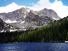
gorgeous setting in forests on the west side of Wild Basin. The trail is well maintained to the patrol cabin at the lake, and from that point, an unmaintained trail leads to the west end of the lake. |
|||||||||||||||||||||||||||||||||||||||||||||||||
 |
|||||||||||||||||||||||||||||||||||||||||||||||||
|
|
|||||||||||||||||||||||||||||||||||||||||||||||||
|
|
|||||||||||||||||||||||||||||||||||||||||||||||||
|
Copeland Falls (0.3 miles one-way from trailhead) Calypso Cascades (1.8 miles one-way from trailhead) Ouzel Falls (2.7 miles one-way from trailhead) Junction of Thunder Lake and Bluebird Trails (3.1 miles one-way from trailhead) Junction of Thunder Lake and Lion Lake Trails (4.8 miles one-way from trailhead) |
|||||||||||||||||||||||||||||||||||||||||||||||||
|
Bluebird Lake (6.2 miles one-way from trailhead) - via Thunder Lake and Bluebird Lake Trails Lion Lake #1 (7.0 miles one-way from trailhead) - via Thunder Lake and Lion Lake Trails Boulder-Grand Pass (8.0 miles one-way from trailhead) - via unmaintained route past Thunder Lake |
|||||||||||||||||||||||||||||||||||||||||||||||||
|
North Saint Vrain (3.5 miles one-way from trailhead) - 2 individual sites Thunder Lake (6.8 miles one-way from trailhead) - 1 group site and 4 individual sites |
|||||||||||||||||||||||||||||||||||||||||||||||||
|
|
|||||||||||||||||||||||||||||||||||||||||||||||||
|
Allenspark. Turn west on to Wild Basin Road from Colorado Highway 7, at a junction about 13 miles south of Estes Park. Continue west to the Copeland Lake area, roughly one-half mile from Highway 7. The Wild Basin trailhead is about 2 miles beyond Copeland Lake on a narrow gravel road. The trailhead begins on the south end of the parking area at the Wild Basin Ranger Station. Access to this parking area may be limited during seasons when snowfall is still present. The Thunder Lake Trail leads past Copeland Falls, Calypso Cascades, and Ouzel Falls before reaching a junction with a trail to Bluebird Lake. Continue toward Thunder Lake, crossing North Saint Vrain Creek, and eventually reaching another junction. At this second major junction, with the trail to Lion Lake #1, take the left-hand trail and continue toward Thunder Lake. Note that there is an unmaintained trail for backpackers that connects on both ends to the Thunder Lake trail. This trail runs from west of Copeland Falls to near the North Saint Vrain campsite area. The Thunder Lake Trail is more well graded than this alternate trail. |
|||||||||||||||||||||||||||||||||||||||||||||||||
|
|
|||||||||||||||||||||||||||||||||||||||||||||||||
|
|
|||||||||||||||||||||||||||||||||||||||||||||||||
 |
 |
||||||||||||||||||||||||||||||||||||||||||||||||
|
|
|||||||||||||||||||||||||||||||||||||||||||||||||
|
|
|||||||||||||||||||||||||||||||||||||||||||||||||
 |
 |
||||||||||||||||||||||||||||||||||||||||||||||||
|
|
|||||||||||||||||||||||||||||||||||||||||||||||||
|
|
|||||||||||||||||||||||||||||||||||||||||||||||||
|
|
|||||||||||||||||||||||||||||||||||||||||||||||||
|
|
|||||||||||||||||||||||||||||||||||||||||||||||||
 |
|||||||||||||||||||||||||||||||||||||||||||||||||
|
|
|||||||||||||||||||||||||||||||||||||||||||||||||
 |
|||||||||||||||||||||||||||||||||||||||||||||||||
 |
|||||||||||||||||||||||||||||||||||||||||||||||||
 |
|||||||||||||||||||||||||||||||||||||||||||||||||
|
|
|||||||||||||||||||||||||||||||||||||||||||||||||
|
|
|||||||||||||||||||||||||||||||||||||||||||||||||
|
|
|||||||||||||||||||||||||||||||||||||||||||||||||
|
Topographic map is property of and copyrighted by Maps a la carte, Inc., and is used on this site with permission. |
|||||||||||||||||||||||||||||||||||||||||||||||||